Update May 2025…
Since I posted this article and sent it to various Government departments and MPs, the Government’s Department Natural England has now released an interactive map of peatlands across England, this is a fantastic new step in understanding land across the UK to make more informed decisions.
My original article…
Recently I asked the Government Department for Energy Security & Net Zero for their map of potentially suitable sites for onshore wind and solar farms. A map based on widely available data on wind strength, topography, nature protections etc. Bearing in mind this is the department we have all entrusted with our energy security, their response literally blew my mind:
Government does not routinely collect or manage information on the suitability of locations for onshore wind sites in the UK.
Department for Energy Security & Net Zero, 2024
What? The very department responsible for getting the UK to net zero and protecting us from risks to energy security in 2024, against the recent threats to it, does not collect any of this data. How can that be possible? This is basic stuff, the data has been widely available from countless sources for decades. To not have this data is gross incompetence at a national level.
This information applies to house development too. It all starts with a national map of potential sites for new and vital development for the whole country.
Why the UK Government and public need a map of potentially suitable development sites
- Planning Departments cannot make good decisions on proposals without this information: local planning departments cannot make an informed decision on wind and solar farm and housing applications without first knowing and approaching the most suitable sites within their area. Factoring in key information from wind strength and consistency, biodiversity protections and access for construction, maintenance and infrastructure.
- For land owners and communities to know the value of their land: many UK landowners could be sitting on a gold mine by including wind and solar farms or new houses on their land without knowing it. The amount of money a land owner with appropriate land, including community owned land, can make from these developments is huge, multi millions of pounds.
- To prevent unnecessary damage to important land by planning departments making mistakes: without knowing all potentially appropriate land for buildings, wind and solar farms, and making this information available to all land owners, planning departments will make terrible mistakes. They could approve developments on important land for biodiversity in the rush to build, when there were thousands of other better spots nearby.
- Fair and even spread across the UK: every home and community should be able to see a fair and equal share of new housing and renewable energy development from their property. This is both to ensure some communities in the UK aren’t dumped upon by too much development, and to ensure other communities don’t miss out from the benefits, such as investment money.
- Tracking total developments: by tracking this data in an easily accessible format now, Government and public can track what’s happening in the future to see the balance between development and increasing biodiversity through restoring land for nature is done correctly.
How can UK Government produce such a map for UK investors, land owners and wider public?
This information is already available. Held within various databases, UK land has been mapped and categorised for hundreds of years. Friends of the Earth have begun creating a simple, if currently flawed, map of potential sites in England for more renewable energy (they have a page explaining the methodology).
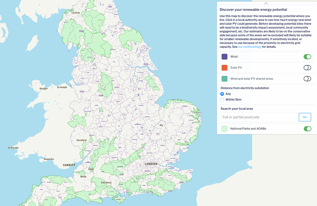
It would be easy for UK Government to collate this data to form part of their national strategy. I’d expect that with a working group of organisations they could create a draft map in as little as a week, a more detailed one in a month, and roll it out to investors, landowners and wider public in almost no time at all.
For instance, we’ve known for a long time:
- Where the best sites are for wind power and sun light levels
- Brown field and low importance land for building
- Agricultural land that could be dual use with renewable energy
- We know our topography
- We know our road and utility infrastructure for easiest construction and long term maintenance
- We know where our most important wildlife sites are for biodiversity to avoid
Satellite data has been collecting information down to the exact number of trees in forests for years as well as changes to land. We have more data than we could ever need. For example DEFRA’s Magic Maps tool has a lot of this information already.
How would the map be used?
The map does not mean all of the sites on it can suddenly be built upon, local planning still applies. A map would simply inform everyone that certain land is suitable for such development allowing the land owners to make an informed decision and step forward. It is a key first step in a joined up national strategy for the future.
Government and local authorities can play a role by connecting land owners with investors who want to build renewable energy and housing developments. Of course, both national and local Government need to make sure this is done with communities in mind, to make sure the community benefits financially too.
As development begins, the national map can then be used to track developments and land restoration to check there is a good balance across the UK. Joined up thinking on a national level will ensure an even spread of development and biodiversity gains for all communities.
Only once these steps have been taken, can planning departments consider developments going on more valuable sites as a last resort. To jump into developing on important sites over less important ones, without first considering all sites across the UK and asking all landowners with more appropriate sites to step forward, would be a big mistake, it would be incompetence.
This does not need to take long, in the hands of the right experts this information could be pulled together quickly and built upon in future years. It would actually help speed up development across the UK.
Could this be done by local council planning departments?
No. Local councils do not have the resources to pull together or pay for the data available alone, and by working in isolation only in their area they will make mistakes by not considering all potential sites around the UK.
For instance, our local council in Calderdale, sent me the below map of potential wind and solar sites in our area, it is deeply flawed:
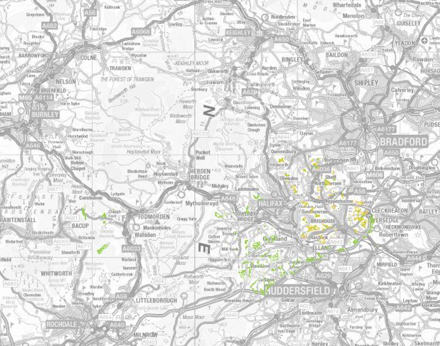
This map only shows sites for small or very small wind turbines (e.g. the smallest domestic ones) based on a survey conducted by a small number of people. As you can see, it misses out huge areas and doesn’t show the hundreds of existing industrial turbines on wind farms. It doesn’t consider the potential sites across the neighbouring areas. It is incorrect because there are lots of other sites not marked on here that would be perfectly suited to wind development that have been missed off.
How can a UK map of potential sites be made?
The steps are incredibly easy, I hope it is one of the first things the new Government does when in power and I’ve written to Ed Miliband saying this, he will be the Secretary of State for Energy Security and Net Zero when in Government. Steps include:
- Identify the best existing databases (many specialists will be able to advise on this)
- Bring the owners of those databases together into a room to then discuss the data
- Decide how it is best integrated into a single Government database
- Implement it and make the map and data available to the public
If you haven’t worked with mass databases or technology like this before, I know it might sound complicated but I have worked with this kind of information and I can assure you, it isn’t.
It needs the right team of people working on it, but in the right hands this is a tool that could set the UK on an informed, intelligent path for future energy security and housing.


Surely the issue is the Tory Government is protecting its mates in the Home Counties from on shore development of wind farms, solar farms and new towns.
In the north of the UK anything goes we are surrounded in Bury with wind farms, housing developments etc. I’m not unhappy with this we are doing our share but the lack of a plan by this government appalls me
Anthony
The lack of national plan by the Conservative Government for development across the UK will go down in history as one of their greatest incompetences. But Labour haven’t said they will have one yet either, so we wait and see…